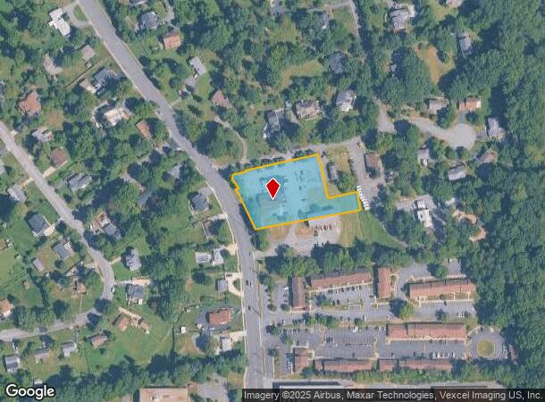
Property Record
5001 Backlick Rd, Annandale, VA 22003
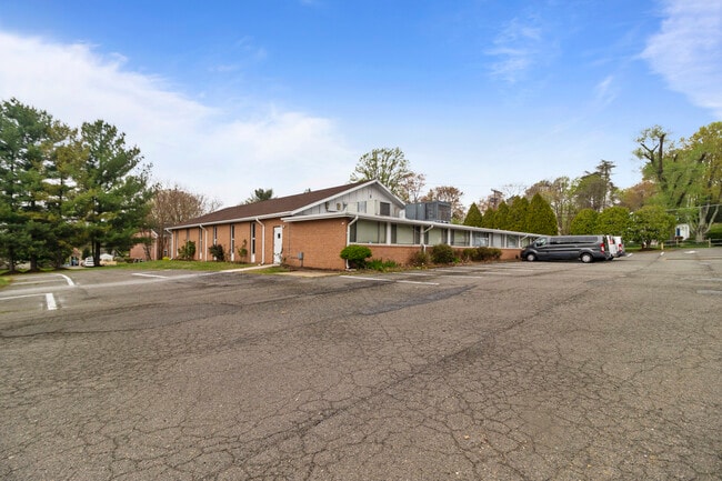
This Property Is For Sale
NEARBY LISTINGS FOR SALE OR LEASE
-
-
View all Annandale listings for sale on LoopNet.com
Property Detail
5001 Backlick Rd
Washington-Arlington-Alexandria, DC-VA-MD-WV
Springfield Parsonage And Ch
0714-01-0021
SPRINGFIELD PARSONAGE AND CH
Religious
Fairfax
X
Virginia
5100540050D
21
0
1.62 AC
2025
Annandale
452101
Washington, DC
7,444 SF
DEMOGRAPHICS near 5001 Backlick Rd
1 Mile
3 Mile
5 Mile
2024 Total Population
11,966
132,173
436,937
2029 Population
11,788
129,845
429,978
Pop Growth 2024-2029
(1.49%)
(1.76%)
(1.59%)
Average Age
42
40
39
2024 Total Households
3,761
45,377
163,890
HH Growth 2024-2029
(1.62%)
(1.98%)
(1.72%)
Median Household Inc
$137,466
$112,441
$112,915
Avg Household Size
2.90
2.80
2.60
2024 Avg HH Vehicles
2.00
2.00
2.00
Median Home Value
$634,637
$609,385
$622,442
Median Year Built
1968
1968
1973
Nearby Places
- Restaurants
- Banks
- Shops
- Fitness
- Groceries
PUBLIC TRANSPORTATION
COMMUTER RAIL
Backlick Road (Manassas Line - Virginia Railway Express)
DRIVE
WALK
Distance
Backlick Road (Manassas Line - Virginia Railway Express)
5 min
1.6 mi
Rolling Road (Manassas Line - Virginia Railway Express)
DRIVE
WALK
Distance
Rolling Road (Manassas Line - Virginia Railway Express)
12 min
5.7 mi
AIRPORT
Ronald Reagan Washington Ntl
DRIVE
WALK
Distance
Ronald Reagan Washington Ntl
19 min
10.3 mi
Washington Dulles International
DRIVE
WALK
Distance
Washington Dulles International
40 min
24.1 mi
Baltimore/Washington International Thurgood Marshall
DRIVE
WALK
Distance
Baltimore/Washington International Thurgood Marshall
68 min
44.1 mi
Freight Ports
Port of Baltimore
DRIVE
WALK
Distance
Port of Baltimore
77 min
55.6 mi
Nearby Properties
Address
Land Use
TOTAL SIZE
Lot Size
Zoning
Address
Land Use
TOTAL SIZE
Lot Size
Zoning
824,193 SF
16.06 AC
400
Address
Land Use
TOTAL SIZE
Lot Size
Zoning
613,844 SF
499
Address
Land Use
TOTAL SIZE
Lot Size
Zoning
1,031,040 SF
36.16 AC
220
Address
Land Use
TOTAL SIZE
Lot Size
Zoning
853,724 SF
32.32 AC
220
Address
Land Use
TOTAL SIZE
Lot Size
Zoning
429,735 SF
20 AC
560
Address
Land Use
TOTAL SIZE
Lot Size
Zoning
329,637 SF
23.39 AC
316
Address
Land Use
TOTAL SIZE
Lot Size
Zoning
431,097 SF
16.45 AC
220
Address
Land Use
TOTAL SIZE
Lot Size
Zoning
452,682 SF
20.74 AC
220
Address
Land Use
TOTAL SIZE
Lot Size
Zoning
415,368 SF
21.06 AC
220
Address
Land Use
TOTAL SIZE
Lot Size
Zoning
485,839 SF
22.59 AC
460
Address
Land Use
TOTAL SIZE
Lot Size
Zoning
485,499 SF
19.11 AC
220
Address
Land Use
TOTAL SIZE
Lot Size
Zoning
8.03 AC
RC
Address
Land Use
TOTAL SIZE
Lot Size
Zoning
511,000 SF
34.16 AC
596
Address
Land Use
TOTAL SIZE
Lot Size
Zoning
10.39 AC
Address
Land Use
TOTAL SIZE
Lot Size
Zoning
253,647 SF
5.99 AC
220
Address
Land Use
TOTAL SIZE
Lot Size
Zoning
263,550 SF
1.78 AC
I
Address
Land Use
TOTAL SIZE
Lot Size
Zoning
5.10 AC
RC
Address
Land Use
TOTAL SIZE
Lot Size
Zoning
325,576 SF
13.06 AC
RA
Address
Land Use
TOTAL SIZE
Lot Size
Zoning
505,632 SF
22.11 AC
RA
Address
Land Use
TOTAL SIZE
Lot Size
Zoning
339,028 SF
75.81 AC
120
Address
Land Use
TOTAL SIZE
Lot Size
Zoning
396,224 SF
6.57 AC
RC
Address
Land Use
TOTAL SIZE
Lot Size
Zoning
281,630 SF
16.07 AC
540
Address
Land Use
TOTAL SIZE
Lot Size
Zoning
398,419 SF
18.54 AC
560
Address
Land Use
TOTAL SIZE
Lot Size
Zoning
246,246 SF
10.84 AC
I
Address
Land Use
TOTAL SIZE
Lot Size
Zoning
124,351 SF
14.60 AC
460
Address
Land Use
TOTAL SIZE
Lot Size
Zoning
153,341 SF
11.96 AC
460
Address
Land Use
TOTAL SIZE
Lot Size
Zoning
106,170 SF
8.39 AC
460
Address
Land Use
TOTAL SIZE
Lot Size
Zoning
253,648 SF
10.72 AC
550
Address
Land Use
TOTAL SIZE
Lot Size
Zoning
7.79 AC
Address
Land Use
TOTAL SIZE
Lot Size
Zoning
268,488 SF
8.57 AC
RA
The World's #1 Commercial Real Estate Marketplace
Connect with us
© 2025 CoStar Group
The information above has been obtained from sources believed reliable. While we do not doubt its accuracy we have not verified it and make no guarantee, warranty or representation about it. It is your responsibility to independently confirm its accuracy and completeness. Any projections, opinions, assumptions, or estimates used are for example only and do not represent the current or future performance of the property. The value of this transaction to you depends on tax and other factors which should be evaluated by your tax, financial, and legal advisors. You and your advisors should conduct a careful, independent investigation of the property to determine to your satisfaction the suitability of the property for your needs.